1964 Alaska Earthquake
Great 1964 Alaska Earthquake
The great 1964 Alaska earthquake occurred in the afternoon. The earthquake began at 5:35 p.m March 27, 1964. It was Good Friday, a holiday in Alaska, and the timing of the earthquake saved many lives.
Many people in Anchorage were home and the schools were closed. Stores were starting to close when the earthquake struck
The earthquake epicenter was at the mouth of College Fiord in Prince William Sound. The megathrust earthquake occurred in an area where the Pacific Plate is subducting beneath the North American Plate.
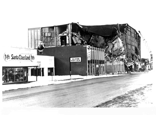
JC Penny store after the 1964 earthquake USGS
Megathrust earthquakes
The 1964 Alaska earthquake was caused by crustal plates moving on the Earth's surface. The North American plate is overriding the Pacific Plate along the coast of Alaska.
One of the keys to understanding and proving the Theory of Plate Tectonics occurred when the 1964 megathrust earthquake occurred in Alaska. It revealed how the Pacific Plate was forced under the North America Plate during the earthquake.
Scientists studying the earthquake found proof that during a megathrust earthquake the ocean plate is overridden by the continental plate during the earthquake.

|
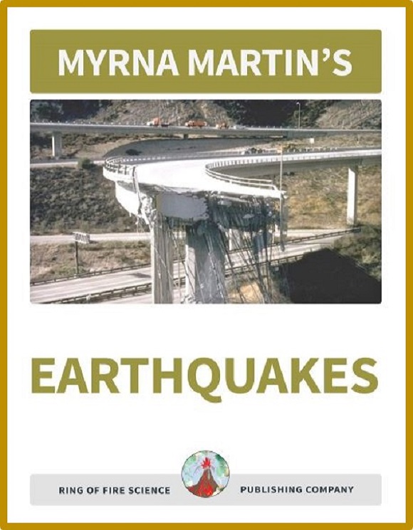
Our SE Earthquakes textbook is designed for students to work through the lesson on thier own with little to no help from their teachers. There are 16 chapters in the book and each chapter contains:
|
Mid-Atlantic Ridge is a mountain range
The Mid-Atlantic Ridge is a mountain range in the middle of the Atlantic Ocean. The Mid-Atlantic Ridge runs from the Arctic Ocean south 10,000 miles (16,000 km) to almost the tip of Africa. The ridge formed on the seafloor. You can walk on the ridge in Iceland.
The lava flowing out of the spreading ridge is from the upper mantle. It forms basalt lava on the ocean floor that is heavier than the continental crust.
The molten rock as it cool forces the continents on both sides of the ridge to move further apart.
Formation of Iceland
Iceland is located over a hotspot and the Mid-Atlantic Ridge. The island has so much molten rock forming from the hotspot and Mid-Atlantic Ridge that it is above the surface of the ocean.
You can visit Iceland and walk across on land from the North American plate to the Eurasian plate.
1964 Alaska Earthquake caused by Mid-Atlantic Ridge
As new land forms on the seafloors at the Mid-Atlantic Ridge
the North American Plate is moving west-southwestward at about 1 inch (2.3 cm) each
year.
The Pacific Plate is moving to the northwestward at a speed of 3 to 4 inches (11 cm) each year.
The moving plates colliding creates stress on the rocks. The seafloor contains basalt rocks that are heavier than the continental crustal rocks. When the two crusts collide the heavier seafloor rocks move beneath the continent.
When the plates become "locked together" stress builds up in the rocks until they break creating an earthquake.
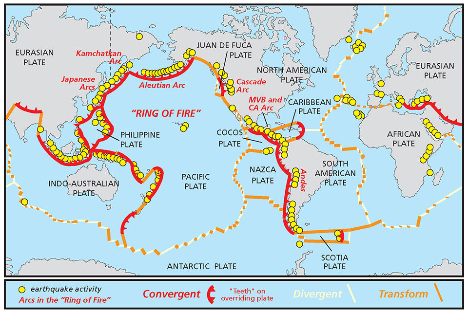
Tectonic plate boundaries map NOAA
Subduction zones in Alaska
Alaska’s has the longest coastline in the United States. It is 66,000 miles long. The coast has a complex history that includes the formation of the Aleutian Islands and the Aleutian Trench.
Epicenter of the 1964 Alaska Earthquake
The epicenter of the earthquake that shook more than half of the state was located in the Prince William Sound on the south flank of the Chugach Mountains.
The origin of the earthquake where the rocks first broke was at a depth between 20-50 km. A broad area of energy from the earthquake was released underlying the Prince William Sound and the Gulf of Alaska.
Aftershocks of the 1964 Alaska Earthquake
The epicenters of aftershocks occurred over 100,000 square miles. Most of these epicenters were on the continental margin of the Aleutian Trench between Prince William sound and Kodiak Island
At the time of the earthquake there were no instruments that could record the ground motion during the quake. Today, there are instruments that can record the ground motion of earthquakes in the area.
Turnagain Heights landslide
A large landslide occurred in Anchorage that was a strip of coastline about 8,500 feet long. The land dropped down in the area. The area of the landslide extended inland about 900 ft.
Large block of soil that included a thick layer of clay, liquified sands and silts were all found in the slide area.
Deadly tsunami waves
There were 119 people killed by tsunamis. There were only 12 people that lost their lives due to other causes.Most of the people killed by tsunamis were triggered by underwater landslides.
There were low casualties caused by the earthquake
It was a holiday and many people were at home. Schools were closed for the holiday. The tides were low when the earthquake struck. If the earthquake had struck when there was a high tide the sea waves would have been much more severe. Tsunamis killed all but 12 people that died that day during the earthquake.
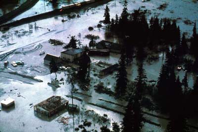
Portage, Alaska after the earthquake USGS
Portage, Alaska once a small town
Today, Portage Alaska is a ghost town. At the time of the earthquake the town was located about 47 miles southeast of Anchorage. The town was located near the seashore and the land sank 6 feet during the earthquake.
Most of the town is underwater at high tide and has been abandoned. All that remains of the town is a few abandoned buildings and a ghost forest. The trees died in the ghost forest died after salt water inundated their root system.
Northwestward movement of the Pacific Plate
The northwestward movement of the Pacific Plate relative to the North American Plate caused the earthquake. The crust of southern Alaska was compressed and warped due to plate movement after the plates locked.
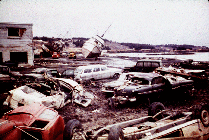
1964 Kodiak, Alaska damage to waterfront USGS
Land affected by the earthquake
Areas along the coast crumpled with some parts uplifted and other parts forming depressions.
Subsidence and uplift affected approximately 250,000 square kilometers of land from Prince William sound to Kodiak Island. Patterns of uplift and subsidence that had been occurring prior to the earthquake reversed. Parts of Montague Island were uplifted between 4 and 9 meters.
The land around the town of Portage subsided by as much as 3 to 9 meters. The picture above of the town of Portage after tsunamis swept over the land.
Tsunami waves generated during the earthquake
Ninety percent of the people that died in the Alaskan earthquake were killed by tsunamis. There were two types of waves generated during the earthquake. The main tsunamis generated by the large-scale movement of the ocean floor.
Tsunami waves swept across the Pacific Ocean. Landslides crashed into bays and fiords minutes after the rupture began generating local tsunamis. The largest wave height was at Shoup Bay which reached 67 meters.
More Earthquake Links
1964 Alaska Earthquake The 1964 Alaska quake was the largest earthquake ever recorded in North America.
Richter Magnitude Scale The Richter magnitude scale was developed in 1935 to study California earthquakes.
Moment Magnitude Scale The moment magnitude scale measures the total energy released by great earthquakes.
Normal Fault Find out how and why normal faults form.
Earthquake Waves Find out which earthquake waves are produced only by large earthquakes.
Earthquake Facts Did you know that an earthquake can occur any place on Earth?
Home Page The Science Site contains information on our planet, volcanoes, science projects, earthquakes and much more.
Kids Fun sCIENCE bOOKSTORE
Check out Myrna Martin's award winning textbooks, e-books, videos and rock sets. The Kids Fun Science Bookstore covers a wide range of earth science topics. Click here to browse.
Sign up to our monthly newsletter and receive our FREE eBook containing 3 fun activities that don’t appear in any of our other books!
The Kids Fun Science monthly newsletter will include the following: current events, weird and fantastic facts, a question of the month, science trivia and the latest new content from our website.
We respect your privacy and you can be assured that we will never share your email address or use it for any other purpose than to send you our newsletter.


